Harvesting ahead of schedule across most of US cotton belt; storms forecast for Delta
According to the latest USDA crop progress report, the condition of the Texas crop further deteriorated during the week ended November 3, with 18 percent of stands rated ‘good to excellent’ (down 2 percentage points on the week) and 27 percent ‘fair’ (1 point lower). Conversely 55 percent of plants were categorized ‘poor to very poor’ (up 5 points on the week). Harvest activities expanded across West Texas, while work was nearing an end elsewhere in the state. Some growers were shredding stalks in fields that were zeroed out, due to drought and/or storm damage late this fall. Statewide, 58 percent of the crop was off the stalk, up 10 points on the week and 9 points ahead of the five-year average.
As clouds cleared across West Texas overnight, temperatures dropped into the 30°s and 40°s (F), and when combined with winds of between 20 and 30 mph, it felt as if readings were around freezing to slightly above. Sunny skies and slightly below-average highs for this time of year are expected today, with temperatures projected in the 60°s (F). Soft soils, therefore, will begin to firm under the open, warmer weather, and the sun will help bleach any discolored lint in open bolls. Another cold front, though, is forecast to enter the region later this week, and light to moderate precipitation is projected. Growers, therefore, are anxious to get as much cotton off the stalk as possible ahead of the next round of rain, and as a result, harvest activities will likely resume as soon as fields are able to support heavy machinery.
Gusting winds were reported in northern parts of the Memphis Territory overnight, and cloudy, breezy conditions are expected today. There is a 70 to 100 percent chance of thunderstorms developing this afternoon and into the evening, and rain accumulations between 0.50’’ and 1.50’’ are projected. Some storms could become severe, with damaging winds and brief, heavy downpours. Pickers, therefore, have been working after dark, and many are rushing today to get as much of the remaining cotton harvested before the storms arrive. As of November 3, picking continued ahead of schedule across the Delta, ranging from 78 percent in Tennessee to 95 percent in Louisiana. Although some growers have finished harvesting, others still need a couple weeks of open, warm weather before picking draws to a close. However, intermittent rains are in the seven-day forecast, which will further delay the season and could adversely affect the quality of remaining lint in open bolls.
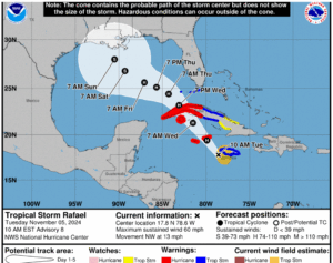
Tropical Storm Rafael developed in the Caribbean Sea last night, and according to the National Hurricane Center, it is tracking in a Northwest path towards Cuba, where it is expected to move across tomorrow afternoon. Once Rafael enters the Gulf of Mexico, it is projected to further intensify in the warm waters as it tracks towards the US Gulf Coast. Although it is still too early to project the strength and exact path, as of 7:00 AM EST, Rafael was projected to make landfall somewhere along the Louisiana/Mississippi Gulf Coast this weekend.
In the Southeast, harvesting was reported from 42 percent in North Carolina to 69 percent in Alabama as of November 3. Partly to mostly cloudy skies are expected across the region today, and stormy weather is in the near-term forecast. Moderate to heavy rain is projected in the upcoming days, with some areas possibly receiving several inches in the upcoming days. Hence, producers are rushing to get as much cotton off the stalk as possible before the inclement weather arrives.
Posted in: Cotlook Headlines News

Leave a Reply
You must be logged in to post a comment.